


Why Accurate Surveying is the Backbone of Successful Dubai Projects
In a city known for its towering skyscrapers and ambitious infrastructure, precision in construction isn’t just a preference, it’s a necessity. Surveying plays a pivotal role in ensuring every project starts on solid ground. From measuring land accurately to mapping out complex structures, modern surveying techniques have transformed how cities like Dubai are built. In this blog, we explore how contemporary survey methods contribute to successful construction, highlighting the importance of surveying and specialized services like total station survey in Dubai.
With rapid urbanization and high-value projects becoming the norm, even minor inaccuracies can lead to significant delays and cost overruns. Modern surveying not only provides accurate measurements but also helps in risk assessment, project planning, and resource optimization. By leveraging advanced tools and technology, developers can anticipate challenges, enhance safety, and ensure structures are both resilient and sustainable. Ultimately, precise surveying lays the foundation for architectural excellence and efficient urban development, turning ambitious visions into reality.
Understanding the Basics: Why Surveying Matters
Imagine trying to build a house on uneven land without knowing the exact dimensions or elevations. The result could be disastrous. This is where basic surveying comes into play. It involves measuring and mapping land to establish boundaries, elevations, and layouts. Surveying ensures that construction starts with precise information, reducing errors and costly adjustments later.
A practical example is the planning of residential complexes. Before digging foundations, surveyors map out the terrain, identify slopes, and note natural features. This foundational step prevents structural issues and ensures efficient use of space. For anyone in construction, understanding these basic surveying principles is crucial.
Advanced Surveying Technologies Shaping Modern Projects
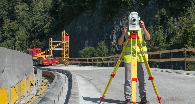
The evolution of surveying has been remarkable. Traditional tools like chains and levels have largely given way to sophisticated instruments such as total stations, laser scanners, and drones. A total station survey allows surveyors to capture highly accurate measurements of distances, angles, and elevations. These devices combine electronic theodolites with distance measurement technology, enabling detailed 3D mapping of sites.
For instance, large-scale commercial projects benefit immensely from these tools. A total station can map complex geometries of a construction site within hours, a task that would take days using older methods. By integrating digital measurements with CAD software, planners and architects can visualize the project before a single brick is laid.
Topographic Surveys: Mapping the Terrain for Success
Topographic surveys are essential when working on uneven or expansive land. They provide detailed maps of the surface, showing natural features like hills, rivers, and vegetation alongside man-made structures. These surveys guide engineers in designing drainage systems, road alignments, and building layouts that work in harmony with the terrain.
Consider a waterfront development in Dubai. Accurate topographic surveys prevent flooding by helping engineers design proper slopes and water channels. Without these insights, projects risk costly errors and delays. This illustrates how modern surveying bridges the gap between vision and reality, ensuring every detail aligns with the environment.
Demarcation and Boundary Accuracy: Avoiding Legal Pitfalls
Accurate boundary identification is not just technical, it’s legal. Demarcation surveys define property lines, preventing disputes and ensuring compliance with regulations. In urban settings, even minor inaccuracies can lead to legal challenges, affecting project timelines and budgets.
Surveyors use a combination of GPS technology and traditional methods to mark precise property lines. This step is crucial for developers and investors, as it secures ownership and avoids conflicts. By prioritizing demarcation, construction projects maintain integrity from the very first survey to final inspection.
Underground and Concrete Scanning: Going Beneath the Surface
Modern construction isn’t limited to surface-level planning. Underground surveys identify utilities, pipelines, and structural elements hidden beneath the ground. Concrete scanning, on the other hand, detects reinforcement bars, post-tension cables, and other embedded materials.
These surveys prevent accidental damage during excavation and drilling, reducing safety risks and project delays. For example, in high-rise construction, knowing the precise location of post-tension cables is critical to avoid compromising structural integrity. Advanced scanning technologies enhance safety, efficiency, and confidence in project execution.
Integrating Survey Data with BIM and GIS
The digital age has revolutionized how survey data is used. Building Information Modeling (BIM) and Geographic Information Systems (GIS) allow survey data to be integrated into comprehensive project plans. Architects, engineers, and contractors can access accurate, real-time information, facilitating better decision-making and collaboration.
This integration is particularly beneficial for complex urban projects where multiple stakeholders are involved. By combining survey precision with digital modeling, teams can anticipate challenges, optimize designs, and reduce unexpected costs.
Surveying for Sustainable Development
Beyond accuracy, modern surveying contributes to sustainable urban planning. By mapping land accurately and assessing environmental factors, surveyors help design energy-efficient buildings, optimize water management, and preserve natural landscapes.
For instance, understanding slope and soil composition can influence building orientation for natural ventilation and sunlight optimization. In this way, surveying doesn’t just support construction, it fosters smarter, eco-friendly urban growth.
Choosing the Right Surveying Partner
Selecting the right team of surveyors is crucial for project success. Professionals combine technical expertise, modern equipment, and local knowledge to deliver precise results. Whether it’s land demarcation, underground surveys, or a total station survey in Dubai, the goal is always to ensure accuracy, efficiency, and compliance.
A reliable surveying partner acts as a foundation for smooth construction, guiding projects from initial measurements to final execution. With the right expertise, developers can avoid costly mistakes and achieve their vision on time.
Conclusion
In the dynamic world of urban development, precision surveying is more than a technical requirement; it’s the backbone of every successful project. From basic surveying to advanced techniques like total station surveys, these services transform ideas into reality with accuracy and efficiency. They help avoid legal issues, enhance safety, and support sustainable planning.
For anyone looking to ensure their project’s success in a fast-growing city, professional surveying services provide the assurance needed to build confidently. By leveraging cutting-edge technology and skilled expertise, projects can rise from concept to completion seamlessly. Discovering the right surveying solutions can make all the difference, and platforms like Lyca Survey connect you with the tools and professionals to achieve excellence in every step.